Trip Overview:
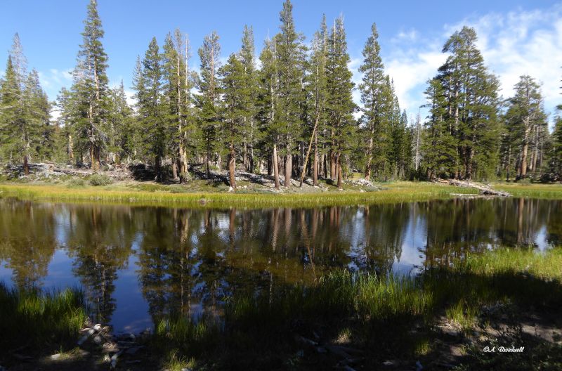
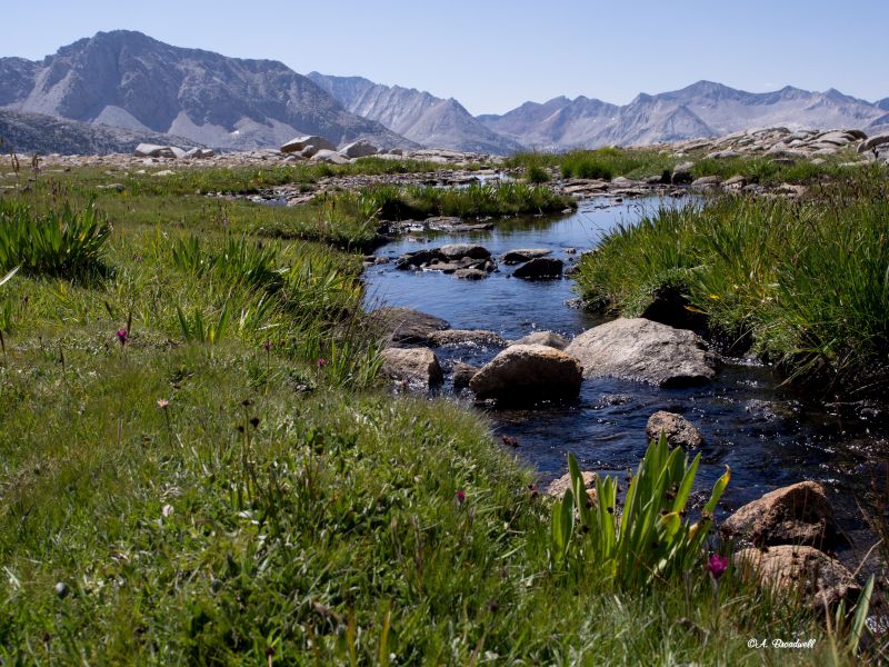
Enjoy traveling along the John Muir Trail without carrying a backpack or eating freeze-dried food. Experience the beauty of countless granite peaks, streams, lakes, forests, and flower-strewn meadows. This 9-day trip accesses the trail from Reds Meadow.
Arrive at Rock Creek Pack Station by 7:00 AM where your gear will be weighed and you will be served breakfast. Your personal vehicles will be left in the pack station parking area.
Begin at Rock Creek Pack Station, ending in Yosemite Valley.
Hikers will be shuttled from Rock Creek Pack Station to Reds Meadow. At the end of the trip all guests will be picked up and shuttled back to the pack station.
Hikers should be able to walk 14 miles with a 1,500 elevation gain and up to 11 miles with as much as 3,500 gain or loss.
You should acclimate to 8,000 to 10,000 for 1-3 days prior to the trip.
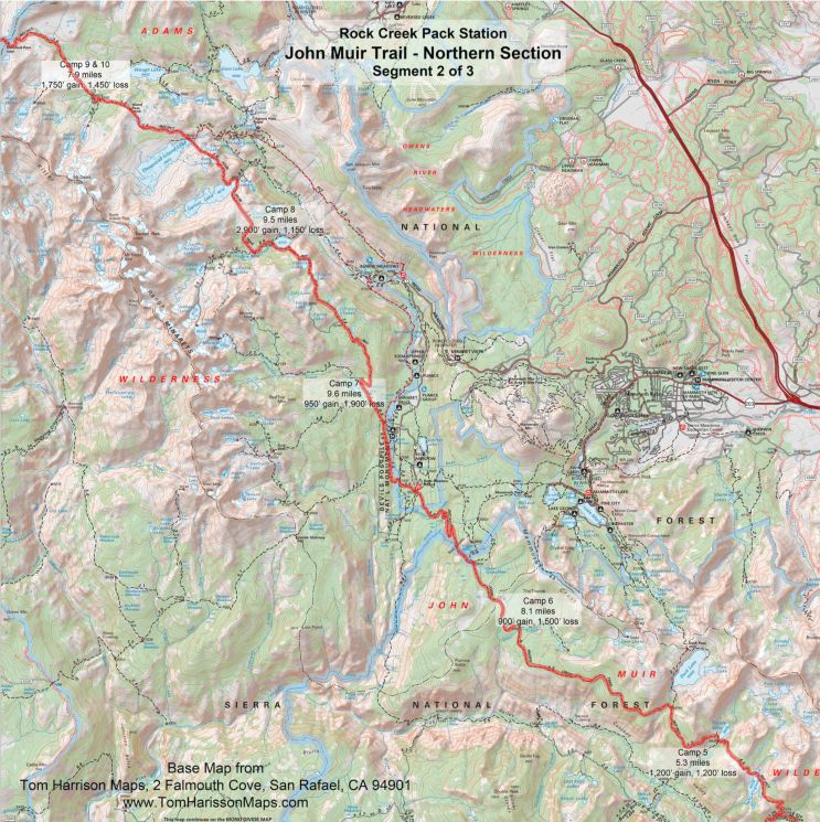
The beautiful Little Lakes Valley hike is an excellent acclimatization hike, starting from the Mosquito Flat Trailhead at 10,250 feet. The trail climbs 500 over 3.5 miles into the glacial canyon past lakes and meadows.
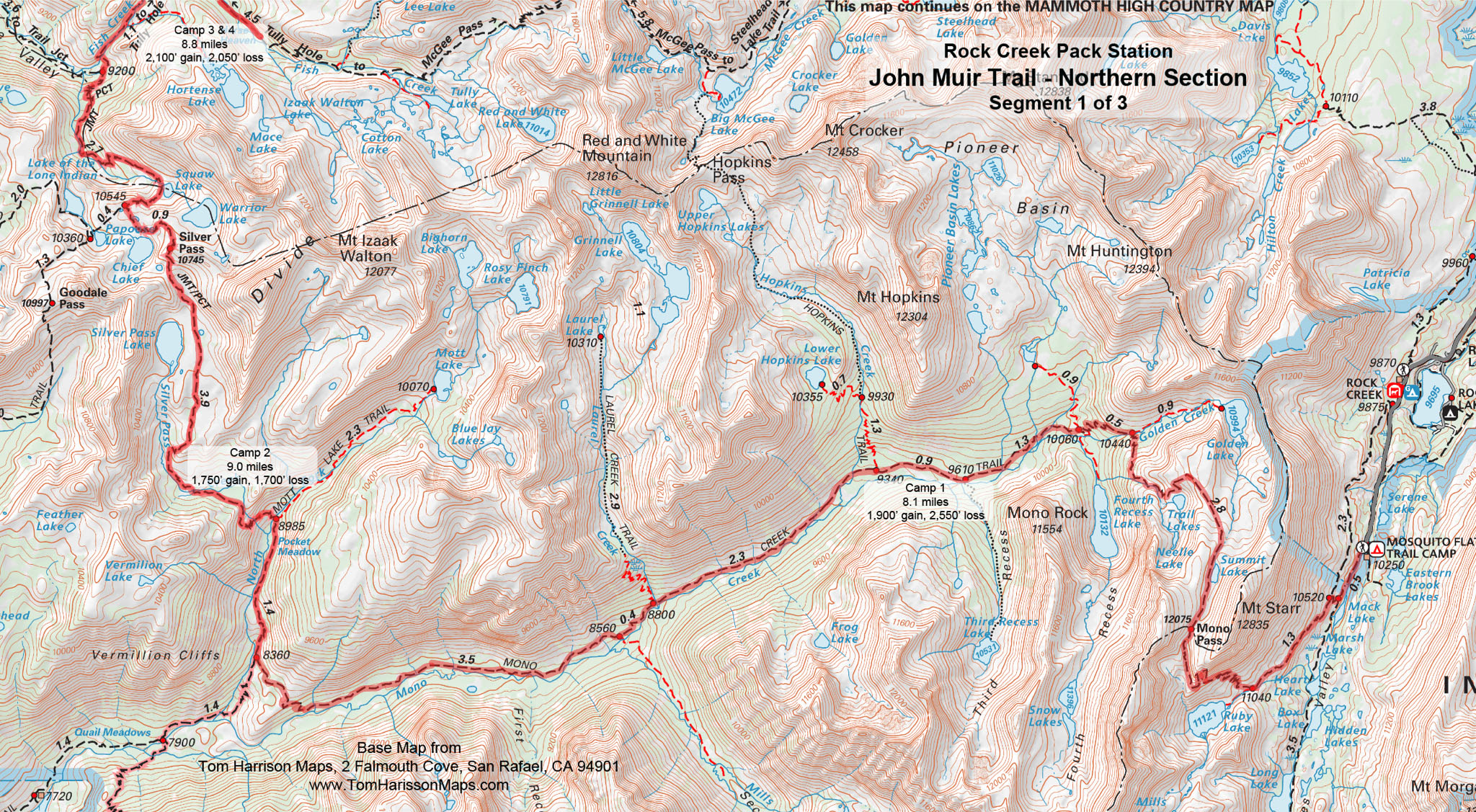
Day 1: Reds Meadow to Johnston Lake
approx 3.6 miles
Follow the John Muir Trail to the fascinating basalt columns of the Devils Postpile, with a possible side trip to Rainbow Falls. Be careful at trail junctions in the Devils Postpile area, as this is where the John Muir Trail and the Pacific Crest Trail separate until the merge again at Thousand Island Lake. Follow the signs to the John Muir Trail and our camp on Johnston Lake.
Be sure to leave Deer Creek with a full water bottle.
Day 2: Johnston Lake to Laura Lake
approximately 9.5 miles, 2,900 gain, 1,150 loss
The next three days take you through the heart of the Minarets area, with wonderful views of the Ritter Range and dozens of beautiful lakes. The trail climbs 1,000 in two miles to a saddle above Trinity Lakes and then continues to climb another 500 to arrive at Gladys Lake at mile 3.8. If you are ready for a break, walk to the east side of Gladys Lake for a great view across the deep canyon of the San Joaquin River. The trail now drops 800 past Rosalie Lake to the junction at Shadow Lake. Follow the JMT to the left to a junction in 0.9 miles. If you are full of energy, go left for a side trip to pretty Ediza Lake, otherwise follow the John Muir Trail to the right toward the saddle above Garnet Lake. Camp will be at approximately 9,900 on Laura Lake. Laura Lake is 0.27 miles past Clarice Lake. (Note that Clarice Lake is a small lake about 0.2 miles to the right of the trail. If you reach the saddle above Garnet Lake, you have passed Clarice Lake by a half-mile).
Numerous lakes and creeks provide ample drinking water.
Day 3: Laura Lake to Rush Creek
7.9 miles, 1,750 gain, 1,450 loss
Plan to spend time enjoying the beauty of the many lakes you will pass today with the Ritter Range always looming to the west. Return 0.5 miles to the John Muir Trail and walk a half mile to the ridge overlooking Garnet Lake. Drop down 300 on easy switchbacks and then parallel the eastern bank, crossing the outlet at mile 1.6. Follow the north shore for 1/3 mile before working your way over the 400 ridge to rejoin the Pacific Crest Trail at the outlet of Thousand Island Lake at mile 3.8. An easy 400 walk up to Island Pass before dropping down to follow Rush Creek up to camp.
Frequent water crossings provide ample drinking water.
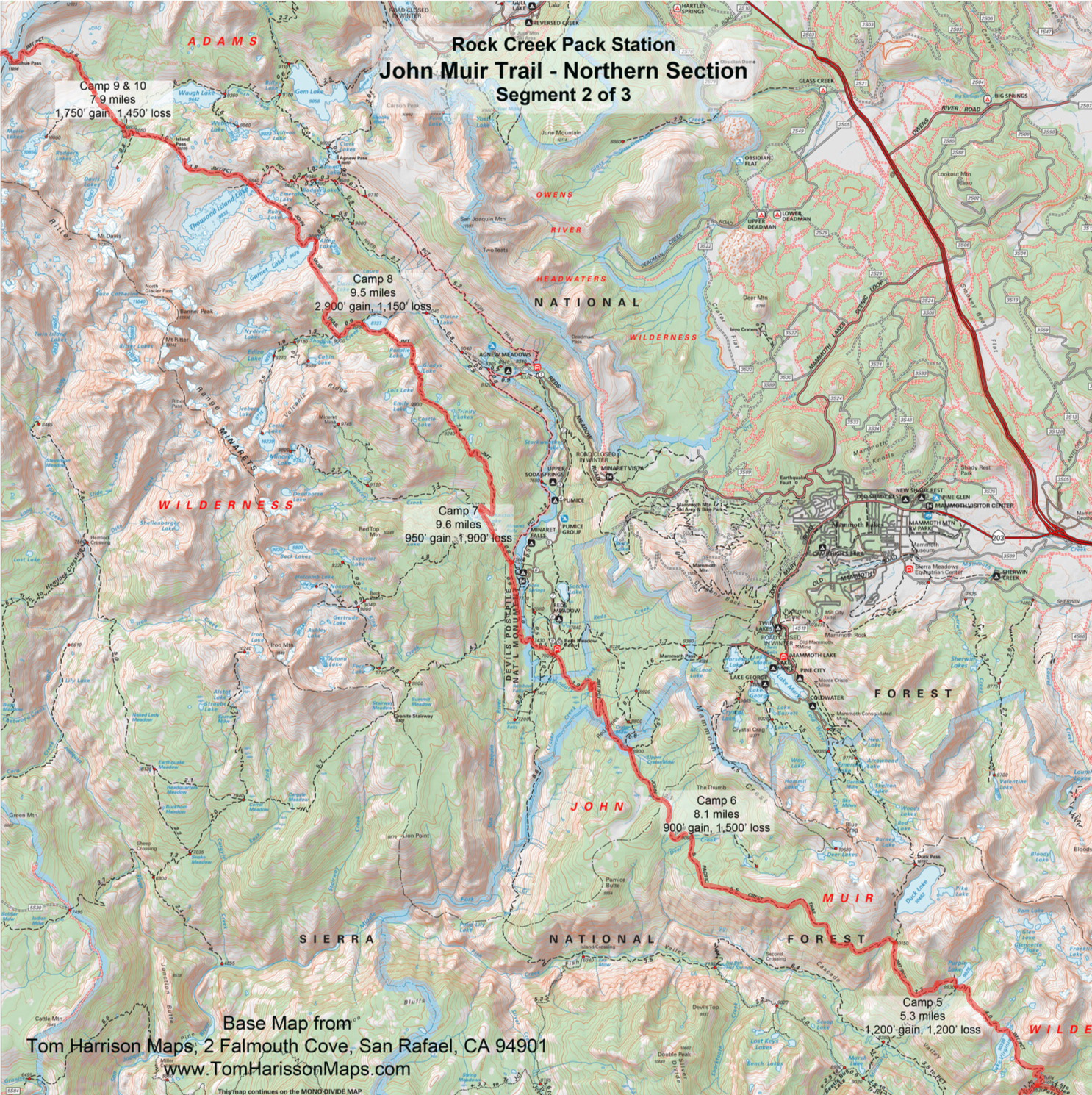
Day 4:Layover Day
The Ritter Range is known for beautiful lake basins. The Marie Lakes (~5 miles RT and 1,000 gain and loss) and the Davis Lakes (~3.5 miles RT and 600 gain and loss) are perfect destinations for a relaxing day by a beautiful lake.
Day 5: Rush Creek to Lyell Canyon
6.7 miles, 1,100 gain, 2,300 loss
The trail follows a creek through high alpine meadows before climbing more steeply to 11,056 Donohue Pass at mile 2.7, the last pass before Tuolumne Meadow. Take one last look at the Ansel Adams Wilderness before stepping into Yosemite National Park. The trail drops 2,200 over the next 3.6 miles through beautiful scenery of creeks, small lakes, and huge slabs of granite, crossing a number of streams, before reaching the meadows of Lyell Canyon. Follow the trail another half mile to a pleasant camp between the trail and the river.
Frequent water crossings provide ample drinking water.
Day 6: Lyell Canyon to Cathedral Lakes
14.4 miles, 1,400 gain, 900 loss
We have spent much of the trip climbing out of canyons up to views of stark granite mountains. Today, the trail follows the long, flat meadows of the Lyell Fork of the Tuolumne River for 7.4 miles, moving between meadows and forest with the meandering river to the right. There is a junction to Ireland Lake and Vogelsang High Sierra Camp at mile 2.3 and then another junction after the Rafferty Creek bridge crossing at mile 6.3. The trail soon approaches the campground, stores, visitor center, etc. of Tuolumne Meadow, but avoids much of the crowd by swinging out into the meadow.
Follow the JMT/PCT to the right at mile 7.4, signed for Tuolumne Lodge, to cross the Tuolumne River on two bridges. Go left at the Gaylor Lakes junction at mile 8.0, crossing the Dana Fork of the Tuolumne River on a bridge at mile 8.1 and then immediately turn left to follow the trail along the river. Cross Highway 120, your first road since leaving Mosquito Flat, and follow the dirt road, passing through the gate at mile 9.5. The John Muir Trail and Pacific Crest Trail once again diverge, this time for good, at mile 9.8 where you will turn left past Soda Springs and Parson s Lodge to follow the trail back across Tuolumne Meadow, crossing Highway 120 again at mile 10.2. The trail tees into the Tuolumne-Tenaya trail in 0.1 miles where you will turn right. The JMT turns left onto the Cathedral Lakes trail in one mile. You will climb 1,000 in three miles to camp near the junction to the Lower Cathedral Lake.
The Tuolumne River is nearby for much of the route.
Mbr>
Leave Tuolumne Meadow with sufficient water for the ascent to Cathedral Lake.
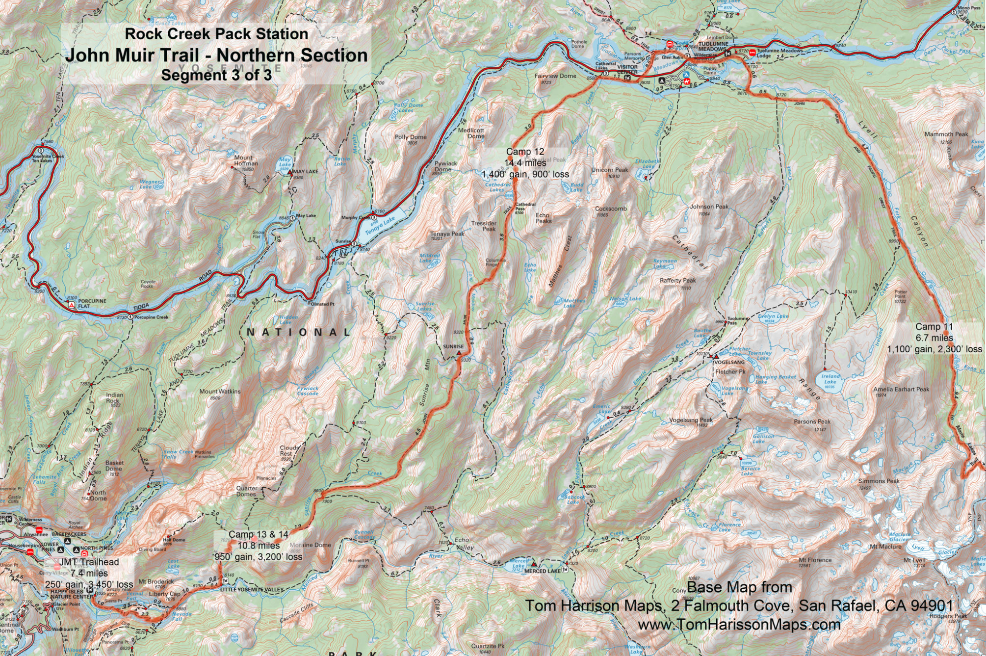
Day 7: Cathedral Lakes to Sunrise Creek
10.8 miles, 950 gain, 3,200 loss
The trail starts out in forest before opening up into the meadow surrounding the upper Cathedral Lake surrounded by Cathedral, Echo and Tresidder Peaks. A short climb to 9,700 Cathedral Pass before dropping down to Long Meadow to pass the Echo Creek junction at mile 3.6 and the Sunrise High Sierra Camp at mile 4.4. The trail climbs 400 over the shoulder of Sunrise Mountain before dropping steadily for 2,500 to camp just short of the Clouds Rest trail junction.
Stream water is usually available during normal water years. Top off your water at the Sunrise High Sierra Camp.
Day 8:Layover Day - Summit Half Dome or Clouds Rest
10.8 miles, 950 gain, 3,200 loss
Follow the John Muir Trail north to the Clouds Rest trail junction at mile 0.1. Those electing to reach the top of Clouds Rest (~7 miles RT and 2,500 gain and loss) will turn right at the junction to follow the trail to the top.
To ascend Half Dome (~5.2 miles and 2,000 gain and loss), continue on the John Muir Trail another 0.5 miles to the Half Dome trail junction. Follow the trail to the right to climb out of the forest to the stark granite of Half Dome. The last section of the trail is over very steep, smooth granite with cables erected for safety, but is not for those with a fear of heights.
Day 9: Sunrise Creek to Happy Isles
7.2 miles, 450 gain, 3,700 loss
Pass the trail junction to Clouds Rest in 0.1 miles and then the Half Dome junction in another 0.5 miles. The trail drops to Little Yosemite Valley where you will turn right at mile 2.1 and then again at mile 2.7 to follow the Merced River to Nevada Fall. Hikers should suppress the urge at mile 3.7 to take the shorter Mist Trail and stay on the John Muir Trail. Cross over the river on the wooden bridge to enjoy a break at the top of the fall before starting down the trail on a series of long switchbacks on the west side of the Merced River. The trail connects with the bottom of the Mist Trail at mile 6.4. Riders will stay on the south side of the river while the hiking trail crosses the river on a wooden bridge with great views of Vernal Fall before dropping down the last 0.7 miles where the two trails merge at the north end of the John Muir Trail at Happy Isles.
Hop on the shuttle or walk the mile to Half Dome (Curry) Village to meet your ride back to the pack station outside the tent cabin check-in counter.
While you are surrounded by crashing water much of the day, be sure to leave the top of Nevada Fall with ample water as there is little access to water until you reach the water fountain at the bridge below Vernal Fall.
What you need to know for hikers on pack stock supported trips
Dunnage limit is 30 lbs. per person (this includes sleeping bags, fishing equipment, liquor, etc.)
You may bring your own tent up to 10 pounds that is in addition. The PCT 28 day trip allows 35 pounds of duffel.
PERSONAL CHECK LIST
Bring belongings in stout canvas or nylon duffels; side zipper recommended, ideal size approximately 14" x 32". It is a good idea to use a large plastic bag INSIDE of the duffle to protect contents from external moisture.
Sleeping bags can be in separate duffels --again, line the inside of the duffle against rain.
Place all cosmetics, soaps, medications, etc into small plastic containers with close-fitting caps, THEN into sturdy resealable plastic storage bags. If anything breaks or bursts from altitude changes, the plastic bag contains the spill.
When possible, it is a good idea to transfer alcoholic beverages to sturdy plastic bottles with well fitting caps - it will save weight and protect against breakage.
ESSENTIALS
- Footwear. For this trips a medium-weight pair of hiking boots. We
do not recommend lightweight hikers or tennies since they give
little ankle support and the soles are often thin.
- Camp Shoes. A lightweight pair of tennies or Tevas to wear in
camp. This will reduce vegetation damage at our campsites.
- A day pack. It should be large enough to take water, extra clothing, rainwear,
camera, etc during the days.
- Sleeping Bag. Most summer trips are warm and a bag rated to
about 25°F will be plenty warm enough. We much prefer down
bags, and good quality ones at that. Your bag should weigh in
around 3 pounds.
- Sleeping pad. A 3/4 or full length closed cell foam or Thermarest.
If you bring a Thermarest also bring a repair kit to fix pesky holes!
- Coffee mug (plastic for camp)
CLOTHING
- 2 pair synthetic liner socks.
- 2 pair heavier synthetic or wool blend socks.
- Long underwear top. Capilene, some other synthetic or the new
pure Merino wool types.
- Long underwear bottom.
- Warm pants. Tights or Expedition Weight Capilene.
- Warm shirt. Synchilla or R2 weight works well.
- Another fuzzy sweater top or pile jacket of some sort
- GoreTex Jacket and Pants. A lightweight set is sufficient and heavy
bulky clothing is unnecessary. Side zips on the pants should be
long enough to slide over boots. Jacket must have a hood. Do not
skimp on your rain gear. Nylon ponchos are not acceptable.
- Shorts for on the trail
- Tee shirt for on the trail
- Lightweight capilene or similar gloves.
- Warm hat. Synthetic or wool.
- Sunhat
ETC.
- Sun glasses.
- Water Bottles. Two quart (1 liter) wide mouth bottles and/or a hydration
system holding up to 50oz. (2 liters). Don t bring bike bottles or
any bottle that doesn t have a wide opening.
- Headlamp. --and a spare set of batteries!
- Pocket knife. Swiss army style.
- Personal toiletries. It is not necessary to smell like a rose each day
so do not over do it.
- Ear plugs are great to have in a noisy tent.
- Personal Medical Kit. The guide will carry a large kit so yours will
predominately consist of foot repair items, mild pain killer such as
Advil and bandaids.
- Sunscreen and lip screen. SPF 30+. A 1oz. bottle will be enough.
Make sure the lip stuff actually contains a sunscreen.
- Bug repellent.
- Camera. A spare battery and card are good backups
- Ski/trekking poles. These are not essential, but can be handy on
the trail. It is your choice, but they do save wear on the knees.
- Plastic trash bag. Handy for keeping gear in outside the tent
should it rain.
- Optional reading material, etc.
FOOD
We provide the all meals on scheduled trips. You can bring
your favorite "on-the-trail" snacks.
OPTIONAL ITEMS
- Small notepad and pencil
- Collapsible plastic wash basin (optional)
- Solar shower (optional)
- Water filtering pump (optional)
- Liquor (be sure to check in with the packers to see that your liquor is packed safely)
- Fishing equipment (optional)
- Rod/reel/line (a rod that breaks down into 3 or more pieces is recommended)
- Compact metal rod case to carry on saddle
- Canvas creel (no tackle boxes)
- Leader material (1-3 lb.)
- Flies: black gnat, mosquito, grey hackle, brown hackle, & royal coachman (No. 12-14 hooks)
- Bait: worms & Pautzke red eggs
- Egg hooks, worm hooks (No. 10-14)
- Split shot
- Lures (personal choice)
- Pliers
TOM HARRISON MAPS.
Map, paper or download onto phone/tablet.
- Mono Divide High Country, Mammoth High Country, and Yosemite High Country or
- John Muir Trail and Mono Divide High Country
National Geographic 308 Yosemite NE: Tuolumne Meadows and Hoover Wilderness Trail Map.
Apps for Smartphone/Tablet, download applicable areas prior to departure:
- Gaia GPS
- Topo Maps
- Guthook s Hiking Guides, PCT Hiker for sections along the PCT
SECTION 1
SECTION 2
SECTION 3