![]()
WILDERNESS PERMITS for our guests are issued from our commercial quota, NOT from the general public quota.
For general mail:
Rock Creek Pack Station
P.O. Box 248
Bishop, CA 93515
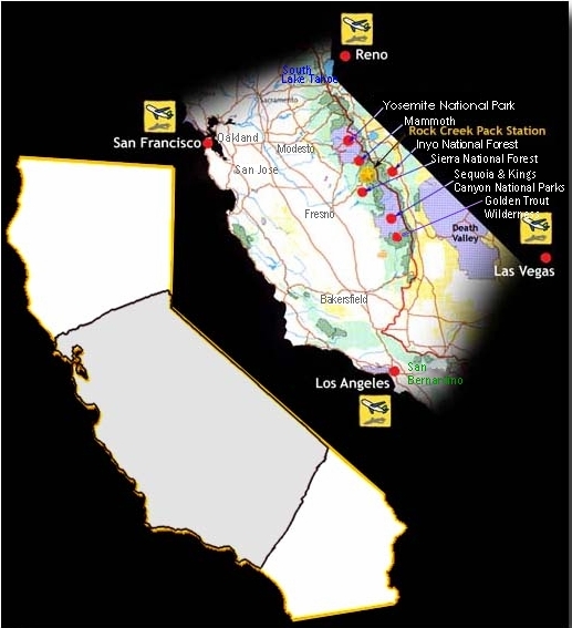
TO REACH ROCK CREEK PACK STATION
Google map link for Rock Creek Pack Station.
By auto: 24 miles north of Bishop take Rock Creek Lake Exit from U.S. 395. Go 10 miles up paved road.
By plane and bus: Both Bishop & Mammoth Lakes airports are within 40 minutes drive.
For commercial flights look at
Mammoth Airport and Reno Airport
(Reno, NV) as destinations.
Eastern Sierra Transit provides bus service to/from points between Reno and Lancaster. Additionally, they offer on-call service within the Bishop Area.
We can pick up guests at Tom's Place.
TO GET TO THE CORRALS AT HORSESHOE MEADOWS
To reach Horseshoe meadows from Lone Pine, CA. In Lone Pine, head southwest on Whitney Portal Road .Continue for 3.1 miles, to Horseshoe Meadows Road. Turn left onto Horseshoe Meadows Road. Note, Horseshoe Meadows Road is 0.4 miles past Movie Road. If you reach Olivas Ranch Road you've gone about 2.4 miles too far.
Continue on Horseshoe Meadows road for 18 miles. This is a steep and somewhat winding road. Google Maps Link for Lone Pine to Horseshoe Meadows
OTHER SERVICES NEAR ROCK CREEK
Meals, lodging, and well-stocked general stores are available at Rock Creek Lodge (ph. 760-935-4170), Rock Creek Lake Resort (ph. 760-935-4311), and Tom's Place Resort (ph. 760-935-4239). Also, there are numerous Forest Service campgrounds in the canyon.
SOME REPRESENTATIVE AREAS
 HILTON LAKES: Trail time: 2-3 hours to any of five lakes over an easy trial through forest and meadow. Recommended for families with young children and novice wilderness travelers. Wonderful areas to camp by either lake or stream on dry benches with sheltering timber, good water and firewood along with good fishing for Brown, Rainbow and Brook trout. Lakes one through nine offer scenery from heavy forest (lakes one and two) to remote glacial stone (upper lakes seven to nine), interspersed with lively streams and lush meadows.
PIONEER BASIN: Trail time: 5 hours to a centrally located camp within easy distance of six lakes. Golden, Rainbow and Brook trout in both lake and stream. Reached via Mono Pass Trail, crossing the summit at 12,000 feet. A primitive, unspoiled country with ample space for privacy and solitude. Shallow, sun-warmed pools for bathing or swimming. Excellent deer hunting.
HOPKINS BASIN: Trail time: 5 1/2-6 1/2 hours, reached via Mono Pass Trail. Beautiful and remote with alternating forests and meadows. Unlimited locations for comfortable camps on Hopkins Creek or Lower Hopkins Lake, situated in a pristine side basin with meadows to the lake's edge on one side, and timber to the water's edge on the other. A favorite of those who seek complete isolation. Golden, Rainbow and Brook trout (some trophy size). Excellent deer hunting in season.
MONO CREEK: Trail time: 4-4 1/2 hours via Mono Pass Trail, which then winds mile after mile by this beautiful stream, in and out of forest stretches, across green meadows and through natural gardens of wild flowers. Limitless camping opportunities alongside excellent fishing streams. Streams from the Recesses, Pioneer Basin, Hopkins Basin, Grinell Basin empty into Mono Creek so that as one travels downstream, its depth and width increases.
TAMARACK LAKES AREA: Trail Time- 2 hours to Dorothy Lake. Lots of meadows, creeks and a variety of ponds and lakes make this a favorite area for those looking for wilderness seclusion. Catherine, Buck, Francis, Dam and Round Lakes are within a short hike from a central camp in the Dorothy Lake area. Ideal for families and those not wanting to cross a mountain pass.
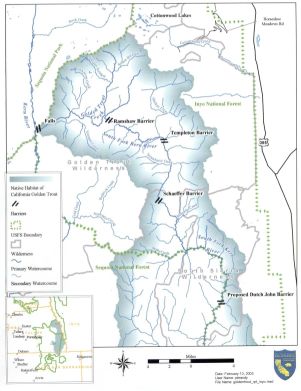
Maps of the Areas we Serve
General Map of Rock Creek's LocationMono Creek Area
Topo Map of Hilton Creek Area (courtesy of Tom Harrison Maps)
Fish Creek Area
Sage Flat Area
Bishop,Taboose, Sawmill and Shepherd's Passes in the Sequoia National Park
Kern Peak Route
NPS Map of Sequoia National Park
Topo map of Sequoia and Kings Canyon National Parks(courtesy of Tom Harrison Maps)
You can email us, also.
Rock Creek Pack Station, Inc operates under permit on the Inyo National Forest.
All Trail Rides and Packing Schools are subject to an 8% regulatory reservation fee, plus 2% USFS fee.
Horse Drives are are subject to an 8% regulatory reservation fee, plus 3% USFS fee.
Mustang Trips are are subject to a 3% USFS fee.
Trips traveling in the Sequoia and Kings Canyon National Parks are subject to an additional 3% park use fee.
NOTICE: In accordance with Federal law and U.S. Department of Agriculture (USDA) civil rights regulations and policies, this institution is prohibited from discriminating on the basis of race, color, national origin, sex, age, disability, and reprisal or retaliation for prior civil rights activity. (Not all prohibited bases apply to all programs.)
Persons with disabilities who require alternative means of communication for program information (e.g., Braille, large print, audiotape, American Sign Language, etc.) should contact the responsible State or local Agency that administers the program or USDAs TARGET Center at (202) 720-2600 (voice and TTY) or contact USDA through the Federal Relay Service at (800) 877-8339. Additionally, program information is also available in languages other than English.
To file a complaint alleging discrimination, complete the USDA Program Discrimination Complaint Form, AD-3027 , found online at http://www.ascr.usda.gov/complaint_filing_cust.html , or at any USDA office or write a letter addressed to USDA and provided in the letter all of the information requested in the form. To request a copy of the complaint form, call (866) 632-9992. Submit your completed form or letter to USDA by: (a) mail: U.S. Department of Agriculture Office of the Assistant Secretary for Civil Rights, 1400 Independence Avenue, SW, Washington, D.C. 20250-9410; (b) fax: (202) 690-7442; or (c) email:program.intake@usda.gov.
USDA is an equal opportunity provider, employer, and lender.
Copyright © 2005-2024 Rock Creek Pack Station - All Rights Reserved